At Category 4, Irma Begins Assault on Florida Keys
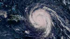
The hurricane's course change catches many off guard and triggers a major round of last-minute evacuations in the Tampa area.ST. PETERSBURG, Fla. — Hurricane Irma began its assault on Florida early Sunday with the storm’s northern eyewall reaching the lower Florida Keys as a powerful Category 4 storm.
Irma lashed the area with maximum sustained winds near 130 mph (215 kph) and the U.S. National Hurricane Center said it was expected to remain a powerful storm as it moved through the Florida Keys and near the state’s west coast.
As of 7 a.m. EDT Sunday, the hurricane was centered about 15 miles (25 kilometers) south-southeast of Key West, Florida, and was moving northwest at 8 mph (13 kph). The Key West International Airport measured sustained winds of 50 mph (80 kph) with a gust of up to 70 mph (113 kph), according to the hurricane center.
Tens of thousands of people huddling in shelters watched for updates as the storm swung to the west, now potentially sparing Tampa as well Miami the catastrophic head-on blow forecasters had been warning about for days.
In the Tampa Bay area, access to all of Pinellas County’s barrier islands, including the popular spring break destination of Clearwater Beach, was shut off.
The leading edge of the immense storm bent palm trees and spit rain across South Florida, knocking out power to more than 430,000 homes and businesses, as the eye approached Key West.
As the hurricane’s eye approached the Florida Keys early Sunday, 60-year-old Carol Walterson Stroud and her family were huddled in a third floor apartment at a senior center in Key West.
“We are good so far,” she said in a text message just before 5:30 a.m. “It’s blowing hard.”
Stroud was with her husband, Tim Stroud, and granddaughter, Sierra Costello. Their dog Rocky was also riding out the storm.
Stroud said she planned to step outside once the eye of the hurricane passed over. She said she has stood in the eye of a hurricane before and it’s “total peace and quiet.”
Florida Gov. Rick Scott had warned residents in the state’s evacuation zones Saturday that “this is your last chance to make a good decision.” About 6.4 million people were told to flee.
But because the storm is 350 to 400 miles wide, the entire Florida peninsula was exposed. Forecasters said the greater Miami area of 6 million people could still get life-threatening hurricane winds and storm surge of 4 to 6 feet.
Irma was at one time the most powerful hurricane ever recorded in the open Atlantic with a peak wind speed of 185 mph (300 kph) last week. It left more than 20 people dead across the Caribbean and as it moved north over the Gulf of Mexico’s bathtub-warm water of nearly 90 degrees, it was expected to regain strength.
Meteorologists predicted Irma would plow into the Tampa Bay area Monday morning. The area has not been struck by a major hurricane since 1921, when its population was about 10,000, National Hurricane Center spokesman Dennis Feltgen said. Now around 3 million people live there.
The latest course also still threatens Naples’ mansion- and yacht-lined canals, Sun City Center’s retirement homes, and Sanibel Island’s shell-filled beaches.
Irma’s course change caught many off guard and triggered a major round of last-minute evacuations in the Tampa area. Many businesses had yet to protect windows with plywood or hurricane shutters. Some locals grumbled about the forecast, even though Florida’s west coast had long been included in the zone of probability.
“For five days, we were told it was going to be on the east coast, and then 24 hours before it hits, we’re now told it’s coming up the west coast,” said Jeff Beerbohm, a 52-year-old entrepreneur in St. Petersburg. “As usual, the weatherman, I don’t know why they’re paid.”
Nearly the entire Florida coastline remained under hurricane watches and warnings, and the latest projections could shift again, sparing or savaging other parts of the state.
Forecasters warned of storm surge as high as 15 feet (4.5 meters).
“This is going to sneak up on people,” said Jamie Rhome, head of the hurricane center’s storm surge unit.
The westward shift prompted Pinellas County, home to St. Petersburg, to order 260,000 people to leave, while Georgia scaled back evacuation orders for some coastal residents. Motorists heading inland from the Tampa area were allowed to drive on the shoulders.
At Germain Arena not far from Fort Myers, on Florida’s southwestern corner, thousands waited in a snaking line for hours to gain a spot in the hockey venue-turned-shelter.
“We’ll never get in,” Jamilla Bartley lamented in the parking lot.
The governor activated all 7,000 members of the Florida National Guard, and 30,000 guardsmen from elsewhere were on standby.
In the Orlando area, Walt Disney World, Universal Studios and Sea World all were closing Saturday. The Miami, Fort Lauderdale, Tampa and Orlando airports shut down.
Given its mammoth size and strength and its course up the peninsula, it could prove one of the most devastating hurricanes ever to hit Florida, and inflict damage on a scale not seen here in 25 years.
Hurricane Andrew smashed into suburban Miami in 1992 with winds topping 165 mph (265 kph), damaging or blowing apart over 125,000 homes. The damage in Florida totaled $26 billion, and at least 40 people died.
___
Reeves reported from Naples. Associated Press writers Seth Borenstein in Washington; Terry Spencer in Palm Beach County; Gary Fineout in Tallahassee; Terrance Harris and Claire Galofaro in Orlando; and Jason Dearen, Jennifer Kay and David Fischer in Miami contributed to this report.
Your support matters…Independent journalism is under threat and overshadowed by heavily funded mainstream media.
You can help level the playing field. Become a member.
Your tax-deductible contribution keeps us digging beneath the headlines to give you thought-provoking, investigative reporting and analysis that unearths what's really happening- without compromise.
Give today to support our courageous, independent journalists.


You need to be a supporter to comment.
There are currently no responses to this article.
Be the first to respond.